The Wilson Map Lab continues a journey that I started 30+ years ago. This journey started with the founding of the Geographic Information and Analysis Center (GIAC) at Montana State University in 1988 and continued with the founding of the GIS Research Laboratory at USC in 1997. This new lab supersedes the GIS Research Laboratory and reflects both the rapidly evolving web-based collaborative landscape we now live and work in and the growth of the USC Spatial Sciences Institute, which today is home to 12 faculty, eight support staff, and over 300 students.
The seeds for my research interests and success were planted long before the establishment of GIAC in 1988. My completion of a M.S. thesis in spatial demography (1979) and a Ph.D. dissertation that combined elements of historical geography, civil engineering, environmental modeling, and geomorphology (1986) speaks to both the breadth of my interests and my willingness to look for the spatial advantage in almost any setting. My work with my own mentors over the first part of my career instilled in me the lifelong goal of using teaching and student participation in research as a way to build capacity and grow leaders in the academic, private, public, and not-for-profit sectors.
I firmly believe the best days are still ahead of us and that the spatial sciences will emerge as a pervasive, cross-cutting and enabling discipline (much like statistics is today). My new virtual lab provides a vehicle to connect faculty, staff and students with projects focused on the modeling of environmental systems, human activity and the built environment, and the environmental and social determinants of human health. These themes fit nicely under the “map” banner because maps promote the production and sharing of knowledge and are embedded in nearly everything we touch.
I work on a variety of projects simultaneously. Most are collaborative in that they involve working with faculty, staff and student colleagues.
1. Projects I embark on because they are fun:
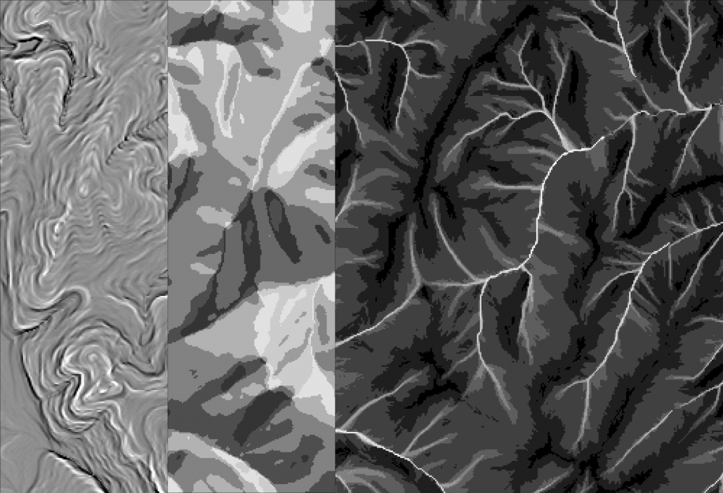
I have sustained a lifelong interest in geomorphometry by conducting a large number and variety of terrain analysis and modeling studies and by writing extensively on these topics. I am currently working on a review article for Progress in Physical Geography and a new digital terrain modeling book for John Wiley and Sons. I have recently co-authored a couple of articles on related topics with Tian-Xiang Yue and colleagues in the Chinese Academy of Sciences.
2. Projects supported by grants and contracts (which may be fun to tackle, as well):
These projects currently include building mobile apps and cloud-based data repositories and mapping platforms to gather and visualize crowdsourced information about places of worship and congregations across the Los Angeles Metropolitan Region, building detailed, photorealistic 3D models of USC’s University Park Campus, and providing place-based assessments linking the built environment, environmental exposures and socio-economic conditions to human health outcomes in studies focused on adolescent smoking vulnerability to tobacco use and marketing across life in one project and maternal stress and children’s obesity risk in another project.
My collaborators include Richard Flory and Brie Loskota (USC Center for Religion and Civic Culture), Kyohyouk Kim (USC Spatial Sciences Institute), Fred Lurmann (Sonoma Technologies, Inc.), and Rob McConnell, Rakesh Ghosh, Genevieve Dunton, Frank Gillilland, Zhenghua Chen, Ed Avol, and Myles Cockburn (USC Department of Preventive Medicine).
3. Student-led projects (which are often fun, as well):
I have the great privilege to work with many students on a great variety of topics. Some the students suggest by themselves, some we develop collaboratively, and all produce some useful knowledge. I am currently working with the following students on Ph.D. dissertation and M.S. thesis projects:
Avery Rose Everhart, Population, Health and Place Ph.D. Program. Dissertation title: Contested care, contingent community: Placing US transgender health care in the global context through a rights-based approach to health.(Co-advisor with Dr. Laura Ferguson, Department of Population and Public Health Sciences, University of Southern California).
Leo Lerner, Population, Health and Place Ph.D. Program. Dissertation title: To what extent can wicked problems of health and place be addressed through clumsy solutions? Three experiments in redistributing networks of knowledge production (Co-advisor with Dr. Lourdes Baezconde-Garbanati, Department of Population and Public Health Sciences, University of Southern California).
Cari Porter, M.S., Geographic Information Science and Technology Program. Thesis title: Place-based flood vulnerability in the Sacramento-San Joaquin Delta region.
Mengya Xu, Population, Health and Place Ph.D. Program, Dissertation title: Availability, diversity, and structure of the retail food environment and associated disparities in Los Angeles County. (Co-advisor with Dr. Kayla de la Haye, Department of Population and Public Health Sciences, University of Southern California).
Yan Xu, Population, Health and Place Ph.D. Program. Dissertation title: Personal PM2.5 exposure assessment of low-income Hispanic pregnant women in Los Angeles. (Co-advisor with Dr. Rima Habre, Department of Population and Public Health Sciences, University of Southern California).
Li Yi, Population, Health and Place Ph.D. Program. Dissertation title: Investigating daily effects of activity space-based built environment exposures on energy-balance behaviors in low-income Hispanic women of childbearing age. (Co-advisor with Dr. Genevieve Dunton, Department of Population and Public Health Sciences, University of Southern California).
4. Projects for which funding proposals have been submitted (which will be fun if they are funded):
My career seems to have come full circle during the past three decades. I had fantastic success early in my career by teaming up with more senior colleagues such as Gerry Nielsen and Steve Custer and now I find fantastic young colleagues wanting to write proposals and to collaborate with me. There are two proposals under consideration for funding now that I am particularly excited about and I would love to see funded so we could tackle the work itself:
A New Approach for Understanding High-Risk Geospatial Decision Making
Jordy Hendrikx, Department of Earth Sciences, Montana State University, Jerry Johnson, Department of Political Science, Montana State University, and John P. Wilson, Spatial Sciences Institute, University of Southern California, PIs
The Power-Water-Climate Nexus: Developing an Integrated Assessment Tool for Analyzing Climate-related Impacts, Vulnerabilities, and Adaptation Strategies in the Power Sector
Kelly Sanders, Department of Civil and Environmental Engineering, University of Southern California and John P. Wilson, Spatial Sciences Institute, PIs
Lab Leadership

Professor of Spatial Sciences, Sociology, Architecture, Civil & Environmental Engineering, and Computer Science

GIS Project Specialist
Current and Alumni Lab Members

Alex Chen
B.S. in GeoDesign 2018

Austin Chow
B.S. in GeoDesign 2019

Courtney Fassett
B.S. in GeoDesign 2020

Eliza Gutierrez-Dewar
B.S. in GeoDesign 2019

Erin Erickson
B.A. in Sociology 2020. B.A. in NGOs & Social Change 2020

Grace Corsi
B.S. in GeoDesign 2019. B.A. in Jazz Voice 2019

Izzy Mitchell
B.S. in GeoDesign 2017. Employed by the City of Los Angeles Mayor's Office as Data Services Lead.

Joanna Wang
B.S. in GeoDesign 2018

Leo Ngo
B.S. in GeoDesign 2018. Employed by the City of Los Angeles Department of Sanitation.

Rich Windisch
B.S. in GeoDesign 2018. M.S. in GIST 2019

Robin Franke
B.S. in GeoDesign 2018. M.S. in Planning 2019. Employed by LA Metro.

Sarah Ladhani
B.A. in Architecture 2018. B.A. in Mathematics 2018. M.S. in Civil Engineering 2020

Xinyue Wang
M.S. in Spatial Informatics 2018

Yi Liu
M.S. in Spatial Informatics 2018

Yuhao Liu
M.S. in Spatial Informatics 2018

Diana Kim
B.S. in GeoDesign 2017. Employed by the City of Los Angeles Housing Authority.

Yuqing Qian
M.S. in Spatial Informatics 2017. Employed by Shenzhen Urban Transportation Public Company, Shenzhen, China.
Elizabeth Berson
B.S. in Industrial and Systems Engineering 2020
Modeling Environmental Systems
The various projects organized under this theme span my early career at Montana State University, my career at USC, and my visiting appointment in the Institute of Geographic Sciences and Natural Resources Research at the Chinese Academy of Sciences. The longest running thread has focused on digital terrain modeling and the pending publication of my new book (Environmental Applications of Digital Terrain Modeling – Wiley, 2018) in many ways represents the culmination of 30+ years of work on the methods and applications of digital terrain analysis and modeling. Much of my early work at USC under the environmental systems modeling theme was part of the Green Visions for 21st Century Southern California project (see below for a series of reports that span hydrologic modeling and biological conservation and restoration, and some of my recent work has involved modeling the spatiotemporal variability of carbon stocks and fluxes in China.
*Graduate Student|**Undergraduate Student
Zhang, L.L.*, Yue, T.X., Wilson, J.P., Zhao, N., Du, Z. P., & Liu, X. (2017).A Comparison of Satellite Observations with the XCO2 Surface Obtained by Fusing TCCON Measurements and GOES-Chem Model Outputs. Science of the Total Environment, 601–602, 1575 – 1590.
Zhang, L.L.*, Yue, T.X., Wilson, J.P., Wang, D.Y., Liu, Y., Zhao, N., Liu, D.D., Du, Z.P., Wang, Y.F., & Lin, C. (2016). Modeling of XCO2 Surfaces Based on Flight Tests of TanSat Instruments. Sensors, 16, 1818.
Yue, T.X., Zhang, L.L.*, Zhao, M.W., Wang, Y.F., & Wilson, J.P. (2016). Space and Ground Based CO2 Measurements: A Review. Science China – Earth Sciences, 56, 2089.
Yue, T.X., Zhao, N., Fan, Z.M., Li, J., Chen, C.F., Lu, Y.M., Wang, C.L., Xu, B., & Wilson, J.P. (2016). CMIP5 Downscaling and Its Uncertainty in China. Global & Planetary Change, 146, 130 – 137.
Yue, T.X., Wang, Y.F., Du, Z.P., Zhao, M.W., Zhang, L.L.*, Zhao, N., Lu, M., Larocque, G.R., & Wilson, J.P. (2016), Analysing the Uncertainty of Estimating Forest Carbon Stocks in China. Biogeosciences, 13, 3991 – 4004.
Yue, T.X., Zhao, M.W., Zhao, N., Chen, C.F., Du, Z.P., Song, D.J., Fan, Z.M., Shi, W.J., Wang, S.H., Yan C.Q., Li, Q.Q., Sun, X.F., Yang, H., Wilson, J.P., & Xu, B. (2015). A Review of Recent Developments in HASM. Environmental Earth Sciences, 74, 6541-6549.
Chen, Y., Zhou, Q., Li, S., Meng, F., Bi, X., Wilson, J.P., Xing, Z., & Qi, J. (2014). The Simulation of Surface Flow Dynamics Using a Flow-Path Network Model. International Journal of Geographical Information Science, 28, 2242 – 2260.
Wilson, J.P., & Bishop, M.P. (2013). Geomorphometry. In J.F. Shroder (Ed.), Treatise in Geomorphology. (pp. 162 – 186). San Diego, CA: Academic Press.
Chen, Y., Wilson, J.P., Zhu, Q., & Zhou, Q. (2012). Comparison of Drainage Constrained Methods for DEM Generalization. Computers & Geosciences, 48, 41 – 49.
Wilson, J.P. (2012). Digital Terrain Modeling. Geomorphology, 137, 107 – 121.
Wolch, J., Longcore, T.R., & Wilson, J.P. (2012). Unpaving Paradise: The Green Visions Plan for Southern California. In D. Sloane (Ed.), Planning Los Angeles (pp. 230 – 239). Los Angeles, CA: APA Planners Press.
Longcore, T.R., Kobernus, P., Lam, C.S.*, Polk, E., & Wilson, J.P. (2010). Extracting Useful Data from Imperfect Monitoring Schemes: Endangered Butterflies at San Bruno Mountain, San Mateo County, California (1982 – 2000) and Implications for Habitat Management. Journal of Insect Conservation, 14, 335 – 346.
Nguyen, T.M.*, & Wilson, J.P. (2010). Sensitivity of Quasi-Dynamic Topographic Wetness Index to Choice of DEM Resolution, Flow Routing Algorithm, and Soil Variability. Paper presented at the Ninth International Symposium on Spatial Accuracy Assessment in Natural Resources & Environmental Sciences, Leicester, United Kingdom.
Sheng, J., & Wilson, J.P., 2009. Hydrology and Water Quality Modeling of the Santa Clara River Watershed. Los Angeles, California: University of Southern California GIS Research Laboratory Green Visions Plan Technical Report No. 23.
Sheng, J., & Wilson, J.P., 2009. Hydrology and Water Quality Modeling of the Los Angeles River Watershed. Los Angeles, California: University of Southern California GIS Research Laboratory Green Visions Plan Technical Report No. 22.
Sheng, J., & Wilson, J. P., 2009. Hydrology and Water Quality Modeling of the Calleguas Creek Watershed. Los Angeles, CA, University of Southern California GIS Research Laboratory, Green Visions Plan Technical Report No. 21.
Wilson, J.P., Goldberg, D.W., & Swift, J.N., 2009. Central Cancer Registry Geocoding Needs. Los Angeles, California: University of Southern California GIS Research Laboratory Technical Report No. 13.
Sheng, J., & Wilson, J.P., 2009. Hydrology and Water Quality Modeling of the San Gabriel River Watershed. Los Angeles, California: University of Southern California GIS Research Laboratory Green Visions Plan Technical Report No. 20.
Sheng, J., & Wilson, J.P., 2009. Hydrology and Water Quality Modeling of the Santa Monica Bay Watershed. Los Angeles, California: University of Southern California GIS Research Laboratory Green Visions Plan Technical Report No. 19.
Newell, J., Sister, C.E.*, Wolch, J., Swift, J.N., Ghaemi, P.*, Wilson, J.P., & Longcore, T.R., 2008. Creating Parks & Open Space Using Green Vision Planning Toolkit 1.0. Los Angeles, California: University of Southern California GIS Research Laboratory & Center for Sustainable Cities Green Visions Plan Technical Report No. 18.
Sister, C.E.*, Wilson, J.P., & Wolch, J., 2008. Access Parks and Park Facilities in the Green Visions Plan Region. Los Angeles, California: University of Southern California, GIS Research Laboratory & Center for Sustainable Cities Green Visions Plan Technical Report No. 17.
Sheng, J., & Wilson, J.P., 2008. Watershed Assets Assessment Report. Los Angeles, California: University of Southern California GIS Research Laboratory & Center for Sustainable Cities Green Visions Plan Technical Report No. 16.
Sister, C.E., Wilson, J.P., & Wolch, J., 2007. Park Congestion and Strategies to Increase Park Equity. Los Angeles, California: University of Southern California GIS Research Laboratory & Center for Sustainable Cities Green Visions Plan Technical Report No. 15.
Lam, S.**, Swift, J.N., & Wilson, J.P., 2007. A Digital Soil Map for the Green Visions Plan for the 21st Century Southern California Study Area. Los Angeles, California: University of Southern California GIS Research Laboratory Technical Report No. 5.
Sister, C.E.*, Wolch, J., Wilson, J.P., Linder, A., Seymour, M.*, Byrne, J.*, & Swift, J.N., 2007. Park and Open Space Resources in the Green Visions Plan Area. Los Angeles, California: University of Southern California GIS Research Laboratory & Center for Sustainable Cities Green Visions Plan Technical Report No. 14.
Wolch, J., Devinny, J., Longcore, T.R., & Wilson, J.P., 2004. Analytic Frameworks for the Green Visions Plan. Los Angeles, California: University of Southern California GIS Research Laboratory & Center for Sustainable Cities Green Visions Plan Technical Report No. 1.
Modeling Human Activity and the Built Environment
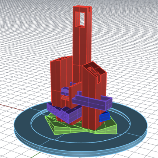
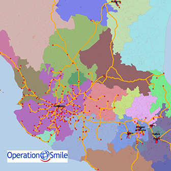
The imprint of people can be found everywhere nowadays – in pristine and celebrated environments like Yellowstone National Park, in our crop and grazing lands, and of course in large metropolitan areas like Los Angeles. This has spawned a variety of projects on 2D and 3D routing, the spatial distribution of tree cover on single family lots in the Los Angeles Metropolitan region, the 3D visualization of a university campus and most recently, the efficacy of Operation Smile’s missions in Mexico and strategies for improving their reach in the coming years.
*Graduate Student|**Undergraduate Student
Shahabi, K.*, & Wilson, J. P. (2018). Scalable Evacuation Routing in A Dynamic Environment. Computers, Environment, and Urban Systems, 67, 29 – 40.
Lee, S.J.*, Rich, C., Longcore, T.R., & Wilson, J.P. (2017).Increased Home Size and Hardscape Decreases Urban Forest Cover in Los Angeles County’s Single-Family Residential Neighborhoods. Urban Forestry & Urban Greening, 24, 222 – 235.
Lin, H., Batty, M., Jorgensen, S.E., Fu, B., Konecny, M., Voinov, A., Torrens, P., Lu, G., Zhu, A.X., Wilson, J.P., Gong, J., Kolditz, O., Bandrova, T., & Chen, M. (2015). Virtual Environments Begin to Embrace Process-based Geographic Analysis. Transactions in GIS, 19, 493 – 498.
Wang, Q., Liu, X., Yue, T.X., Wang, C., & Wilson, J.P. (2015). Using Models and Spatial Analysis to Analyze Spatio-Temporal Variations of Food Provision and Food Potential Across China’s Agro-Ecosystems. Ecological Modeling, 306, 152 – 159.
Kim, K., & Wilson, J.P. (2015).Planning and Visualising 3D Routes for Indoor and Outdoor Spaces Using-CityEngine. Journal of Spatial Science, 60, 179 – 193.
Lue, E.*, Wilson, J.P., & Curtis, A. (2015). Conducting Disaster Damage Assessments with Spatial Video, Experts, and Citizens. Applied Geography, 52, 46 – 54.
Banaei-Kashani, F., Ghaemi, P.*, & Wilson, J.P. (2014). Maximal Reverse Skyline Query. Paper presented at the Twenty-second ACM SIGSPATIAL International Conference on Advances in Geographic Information Systems, Dallas, Texas.
Shahabi, K.*, & Wilson, J.P. (2014). CASPER Intelligent Capacity-Aware Evacuation Routing. Computers, Environment and Urban Systems, 46, 12 – 24.
Ghaemi, P.*, Shahabi, K.*, Wilson, J.P., & Banaei-Kashani, F. (2014).A Comparative Study of Two Approaches for Supporting Optimal Network Location Queries. Geoinformatica, 18, 229 – 251.
Ghaemi, P.*, Shahabi, K.*, Wilson, J.P., & Banaei-Kashani, F. (2012). Continuous Maximal Reverse Nearest Neighbor Query on Spatial Networks. Paper presented at the Twentieth ACM SIGSPATIAL International Conference on Advances in Geographic Information Systems, Los Angeles, California.
Swift, J.N., Wilson, J.P., & Nguyen, T.**(2012).Estimated Temporal Variation of Losses Due to a Recurrence of the 1933 Long Beach Earthquake. Earthquake Spectra, 28, 347 – 365.
Ghaemi, P.*, Shahabi, K.*, Wilson, J.P., & Banaei-Kashani, F. (2010). Optimal Network Location Queries. Paper presented at the Eighteenth ACM SIGSPATIAL International Conference on Advances in Geographic Information Systems, San Jose, California.
Goldberg, D.W.*, Wilson, J.P., & Cockburn, M.G. (2010). Toward Quantitative Geocode Accuracy Metrics. Paper presented at the Ninth International Symposium on Spatial Accuracy Assessment in Natural Resources & Environmental Sciences, Leicester, United Kingdom.
Lee, S.J.*, Longcore, T., & Wilson, J.P. (2010),Identification of Municipal Policies that Influence the Distribution of Green Cover Across Metropolian Regions. International Archives of Photogrammetry, Remote Sensing, and Spatial Information Sciences, 38, Part II, 513 – 518.
Sister, C.E.*, Wolch, J., & Wilson, J.P. (2010). Got Green? Addressing Environmental Justice in Park Provision. GeoJournal, 75, 229 – 248.
Modeling the Environmental and Social Determinants of Health
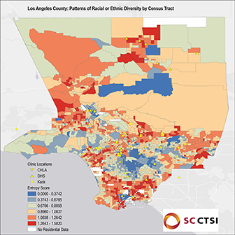
The various projects organized under this theme use a variety of spatial analysis and modeling approaches with geographically referenced data to explore the relationships connecting people, location, time and health. The location is typically cast in terms of their social (i.e. various socioeconomic and demographic variables), behavioral (i.e. lifestyle choices focused on diet, nutrition, and exercise) and environmental characteristics. The latter may include beneficial features such as the quality of the local housing stock and availability and distance to green space as well as adverse traits connected with crime, pollution (i.e. PM2.5 concentrations), toxic substances (i.e. pesticide applications), and UV exposure, among others. This information is used, in turn, to help guide disease prevention, health promotion, and better health care service planning and delivery.
*Graduate Student|**Undergraduate Student
Brandt, S.J., Dickinson, B., Ghosh, R., Perez, L., Lurmann, F., Penfold, B., Wilson, J.P., Millet, M., Künzli, N., & McConnell, R. (2017). Costs of Coronary Heart Disease and Mortality Associated with Near-Roadway Air Pollution. Science of the Total Environment, 601– 602, 391 – 396.
Lue, E.*, & Wilson, J.P. (2017). Mapping Fires and American Red Cross Aid Using Demographic Indicators of Vulnerability. Disasters, 41, 409 – 426.
Chen, Z., Salam, M.T., Toledo-Corral, C., Watanabe, R.M., Xiang, A.H., Buchanan, T.A., Habre, R., Bastain, T.M., Lurmann, F., Wilson, J.P., Trigo, E., & Gilliland, F.D. (2016). Ambient Air Pollutants Have Adverse Effects on Insulin and Glucose Homeostasis in Mexican Americans. Diabetes Care, 39, 547 – 554.
Ghosh, R., Lurmann, F., Perez, L., Penfold, B., Brandt, S., Wilson, J.P., Millet, M., Künzli, N., & McConnell, R.S. (2016). Near Roadway Air Pollution and Coronary Heart Disease: Burden of Disease and Potential Impact of Greenhouse Gas Reduction Strategy in Southern California. Environmental Health Perspectives, 124, 193 – 200.
VoPham, T.M.*, Wilson, J.P., Ruddell, D., Rashed, T., Brooks, M.A., Yuan, J.M., Talbott, E.O., Chang, C.C.H., & Weissfeld, J.L. (2015). Linking Pesticides and Human Health: A Geographic Information (GIS) and Landsat Remote Sensing Method to Estimate Agriculture Pesticide Exposure. Applied Geography, 62, 171 – 181.
Chen, Z., Salam, M.T., Karim, R., Toledo-Corral, C.M., Watanabe, R.M., Xiang, A.H., Buchanan, T.A., Habre, R., Bastain, T.M., Lurmann, F., Taher, M., Wilson, J.P., Trigo, E., & Gilliland, F.D. (2015). Living Near A Freeway is Associated with Lower Bone Mineral Density among Mexican Americans. Osteoporosis International, 26, 1713 – 1721.
Cederbaum, J.A., Petering, R., Hutchinson, M.K., He, A.S., Wilson, J.P., Jemmott, J.B., & Jemmott, L.S. (2015). Alcohol Outlet Density and Related Use in an Urban Black Population in Philadelphia Public Housing Communities. Health & Place, 31, 31 – 38.
Brandt, S.J., Perez, L., Künzli, N., Lurmann, F., Wilson, J.P., Pastor, M., & McConnell, R. (2014). Cost of Near-Roadway and Regional Air Pollution-Attributable Childhood Asthma in Los Angeles County. Journal of Allergy & Clinical Immunology, 134, 1028 – 1035.
Hricko, A., Rowland, G., Eckel, S., Logan, A., Taher, M., & Wilson, J.P. (2014). Global Trade, Local Impacts Lessons from California on Health Impacts and Environmental Justice Concerns for Residents Living near Freight Rail Yards. International Journal of Environmental Research & Public Health, 11, 1914 – 1941.
Dueker, D.*, Taher, M., Wilson, J.P., & McConnell, R.S. (2014). Evaluating Children’s Location Using a Personal GPS Logging Instrument Limitations and Lessons Learned. Journal of Exposure Science and Environmental Epidemiology, 24, 244 – 252.
Raubal, M., Jacquez, J., Wilson, J.P., & Kuhn, W. (2013). Synthesizing Population, Health, and Place. Journal of Spatial Information Science, 7, 103 – 108.
Perez, L., Lurmann, F., Wilson, J.P., Pastor, M., Brandt, S.J., Künzli, N., McConnell, R.S. (2012). Near Roadway Pollution and Childhood Asthma: Implications for Developing “Win-Win” Compact Urban Development and Clean Vehicle Strategies. Environmental Health Perspectives, 120, 1619 – 1626.
Current Contracts and Grants
2021-2026 Southern California Environmental Health Sciences Center: Environmental Exposures, Host Factors, and Human Disease. National Institute of Environmental Health Sciences; Co-PI; R. McConnell, Department of Population and Public Health Sciences, University of Southern California, PI; $8,241,140 ($212,190; Wilson).
2021-2024 Using Community Partnerships, Novel Data Streams, and a Data Portal to Strengthen Food Systems, Security, and Justice. National Science Foundation; Co-PI; K. de la Haye, Department of Population and Public Health Sciences, University of Southern California, PI; $2,054,156 ($654,898, Wilson).
2021-2024 CHES: Community Scholars Collaborative on Healthy Equity. University of Southern California Research Collaboration Fund; Co-PI with L. Amezcua, Department of Neurology, L. Baezconde-Garbanati, Department of Population and Public Health Sciences, Iris Chi, Suzanne Dworak-Peck School of Social Work, Robert Vos, Spatial Sciences Institute, University of Southern California; $30,422.
2021-2023 The Impact of Air Pollution and Neighborhood-Level Risk Factors on Pediatric Perioperative Respiratory Adverse Events. The Anesthesia Patient Safety Foundation and the Foundation for Anesthesia Education and Research Mentored Research Training Grant; Co-PI; Jonathan Tan, Children’s Hospital Los Angeles, PI; $300,000.
2021-2023 Mapping Los Angeles landscape history: A multi-institutional collaboration. John Randolph and Dora Haynes Foundation; Co-PI; P.J. Ethington, Department of History and Spatial Sciences Institute, University of Southern California, PI; $270,828 ($34,000; Wilson).
2021-2022 USC Urban Trees Initiative (Phase II). Public Exchange, Dornsife College of Letters, Arts and Sciences, University of Southern California, PI; $200,000.
2021 Design and Launch of the USC Sustainability GIS Hub. Office of Sustainability, University of Southern California; PI; $9,051.
2021 Modeling the health benefits of traffic related air pollution abatement across the City of Los Angeles. Southern California Environmental Health Sciences Center (Pilot Grant); Co-PI with K. Li, Spatial Sciences Institute, University of Southern California; $30,000.
2020-2022 Design and Launch of the GeoHealth Hub to Support Population, Health and Place Research. USC Addiction Research Center, Norris Cancer Center, and the Southern California Environmental Health Sciences Center; Co-PI with B. MacDonald, Spatial Sciences Institute, University of Southern California; $45,000.
2020-2021 COVID-19 Impacts on Food Access, Food Insecurity, and Informal Food Assistance in Los Angeles County. Keck School of Medicine of USC COVID-19 Research Fund; Co-PI with L. de la Haye, Department of Population and Public Health Sciences, W. Bruine de Bruin, Price School of Public Policy, University of Southern California; $94,105.
2020-2021 Maximizing the Benefits of Increased Urban Canopy on the Eastside of Los Angeles. Sherman Fairchild Foundation and Public Exchange, Dornsife College of Letters, Arts and Sciences, University of Southern California; PI; $50,000.
2020-2021 Geographic Patterns of Food Insecurity during the COVID-19 Pandemic in Los Angeles County. Public Exchange, Dornsife College of Letters, Arts and Sciences, University of Southern California; PI; $75,000.
2020-2021 Using Geospatial Analysis for the City of Los Angeles to Make Data-Driven Decisions and Advance Resilience, Sustainability, and Civic Engagement. University of Southern California Undergraduate Research Associates Program; Co-PI with B. MacDonald, Spatial Sciences Institute, University of Southern California; $9,700.
2020-2021 Using Big Mobility Data to Map Food Environments in Los Angeles: Pilot Study. Keck School of Medicine of USC; Co-I; K. de la Haye, Department of Population and Public Health Sciences, University of Southern California, PI; $40,000.
2019-2023 Contextual Effects on Cardiometabolic Health: Evidence from a Natural Experiment. National Heart, Lung, and Blood Institute, National Institutes for Health; Co-I; A. Datar, Center for Economic and Social Research, University of Southern California, PI; $1,000,000 ($175,200; Wilson).

Latest Projects
